This page gives a summary of any changing planning news in Timsbury.
All applications for land use building and conversions are referred by B&NES Council to the Parish Council for its comment at its next meeting, but B&NES makes the final decisions. Also, applications for tree management within Timsbury’s designated Conservation Area in the old centre of the village are also consulted on.
Details of the Parish Council Agenda and Minutes of its decisions can be seen here. Residents and applicants can ask to make comments at the Parish Council meeting. Contact the Clerk before or at the begining of the meeting.
See more background to planning in Timsbury here.
All decisions are made by B&NES Council based on their Local Plan as mentioned below. See their planning page here, and search for Timsbury.
Timsbury Parish Council’s response to B&NES Local Plan Options, November 2025
Overview
Timsbury Parish Council would recommend the development of between 30 to 50 two and three-bedroom affordable homes for purchase and renting. It could not support more extensive development that would place unsustainable pressure on the existing transport and social infrastructure
Options for development
The Timsbury section of the B&NES Local Plan Options document suggests three possible sites for housing development. Together these could deliver up to 380 additional homes for the village by 2042. This would bring an increase of around one third in homes and residents.
The document stresses that these three sites are options. Decisions to take them forward will depend on infrastructure capacity, environmental constraints and the outcome of further consultation.
Overall assessment
Having considered the options, and made a survey of resident’s views on future development, the Parish Council has focussed its response on infrastructure capacity and concluded that the village cannot sustainably support a substantial increase in housing and population.
The Parish Council recognises that B&NES planners are required to identify sites for 27,000 homes to be built in the area by 2042. However, B&NES connectivity data gives Timsbury a C rating. More robust connectivity data from the Department for Transport, with ratings for employment, education, healthcare and shopping, put Timsbury well down the preference list for additional housing to meet the 27,000 target.
Despite the poor assessment ratings there is a need for more homes in Timsbury to satisfy demand from villagers presently living in overcrowded accommodation. The Parish Council would, therefore, support a development of 30 to 50 two and three-bedroom affordable homes for purchase and renting.
Development opportunities
Having considered the suitability of the three options for new housing and taking note of the results of its resident’s survey, the Parish Council recommends the land to the east of St Mary’s School as the best option. The existing allocation is for approximately 20 homes and there is scope to more than double this number. Access would be onto North Road at the edge of the village and the suggested development is for social housing.
The site at Lippiatt Lane/ Crocombe Lane has capacity for 70 to 90 homes but access is severely restricted both via the narrow Crocombe Lane, which would greatly increase traffic past the village primary school, and the even narrower Lippiatt Lane. Both lanes exit on to an often-congested stretch of North Road.
There appears to be some confusion in the planner’s assessment of Emlett Field. It does not have a strategic location on the A37 corridor and does not have a mixed-use and employment potential. The suggested development for this site is for 120 chiefly larger homes for sale. This would mostly attract new residents to the village and do little to satisfy the demand from existing residents living in overcrowded accommodation.
Constraints
The Parish Council has identified two major constraints, the lack of public transport and the level of traffic congestion along North Road caused by residents travelling to and from the village and by others passing through.
Most of those in employment and all secondary school children travel out of the village and existing morning and evening bus services do not provide for this. Services during the day are relatively few and timing does not encourage use for leisure and shopping trips. More importantly even this inadequate service is under threat since essential funding is not guaranteed beyond 2026. Any increase in the village population will inevitably bring an increase in vehicle traffic. A large increase in population will bring a correspondingly large increase in traffic.
Mitigation
The Options document refers to mitigating the existing problems with traffic on North Road. So far, the Parish Council has been unable to envisage any effective possibilities for worthwhile improvement to this road.
At present the primary school does have capacity for more pupils but limited existing GP provision would be a constraint. This could be addressed but it would probably require larger premises on a different site.
The village cemetery is nearing capacity. It would be a benefit if any substantial increase in housing development could also provide space for a cemetery and for allotments and communal vegetable growing.
The Coal Canal
The Placemaking Plan adopted by B&NES Council in 2017 provided protection for the former route of the Somerset Coal Canal to ensure that further development did not prohibit its eventual reinstatement. The Options document suggests that the protected route be moved away from existing housing. The Parish Council has no objection to the proposed changes to the protected route.
Local Plan Options village meeting
29th September 2025
These are the Microsoft PowerPoint slides that Shaun Stephenson-McGall used for his presentation at the village meeting about the village Local Plan Options on 29th September 2025.
You may download them for viewing offline or you may read them online on this website.
Meeting of the Local Plan Working Group
29th January 2025
Present:
Working Group – Mary-Anne Ansell, KC Bradley, David Collett, Shaun Stephenson-McGall.
Residents – Paul Carroll, John Edmunds, Rachael Le Hurray, Paul Pickett, Ian Scarth,
After making introductions KC set out the objective as the consideration of proposed development on Emlett and asked Shaun to explain our current understanding of the planning rules.
Shaun summarised the position as follows:
Within B&NES Council most planning decisions (around 85%) are made by the planning officers. More contentious issues (around 15%) are decided by the planning committee.
Decisions are determined against planning policy as set out in the agreed Local Plan and the national planning policy. The current B&NES Council five-year plan envisaged the building of 717 new homes each year. Changes recently announced by the Government required that this target be increased to 1,463 new homes each year.
Work on developing a new Local Plan has begun and is expected to take around 18 months to complete. It is likely that in the Plan the new-home allocation to Timsbury will be about 120 to be built by 2042.
Under the current 717-home building target B&NES Council’s five-year housing land supply provision exceeds requirements. When that provision is reviewed in April 2025 against the new target it will be deemed inadequate. As a result, while the existing Local Plan will still be considered when making planning decisions, it will cease to be paramount.
This spring B&NES Council will be unable to demonstrate an adequate five-year housing land supply. It is, therefore, an attractive time for submitting speculative planning applications since there can be no legal evidence to show that an application does not conform to the Local Plan.
In developing the new Local Plan B&NES planners have asked the Parish Council to assess, or reassess, 11 potential village sites under its Housing and Economic Land Availability Assessment. This work has begun and will now be progressed to complete it by the end of March. The results will become part of the evidence used by B&NES Council when making planning decisions.
Subsequent discussion made a range of points:
- Waddeton Park Ltd., the planning applicant for Emlett, is a successful land promoter specialising is securing planning permission. It also purchases land with development potential. Having secured outline planning consent, it sells the land on to a house builder or developer.
- A master plan has been prepared for Emlett showing 120 homes (40% of them affordable) and incorporating lots of green space and environmentally friendly features.
- This plan is unlikely to survive if and when a house builder becomes involved and seeks changes necessary to make the site ‘economically viable’. A proposal for more homes with a lower percentage of affordable homes is to be expected.
- Despite the weakening of the current local plan this application for Emlett will not inevitably be approved and an organised objection can make a difference. Possibly by encouraging the involvement of the Council’s planning committee.
- This application is likely to be the first to be considered by B&NES officers under the new target regime. If it can be allocated to the planning committee for decision this is more likely to result in refusal.
- When the potential Emlett site is assessed according to the B&NES Parish and Town Council Site Assessment Toolkit it is likely to score well on many of the practical segments – flat, well drained, adjacent to existing housing, easy road access, close to bus stops, recreation field, village hall and church. It will score less well on visual amenities, local landmarks and views and historic association.
- When compared with other possible development sites within the village Emlett is the only one with current developer interest.
- If the initial planning application is rejected Waddington Park Ltd. is likely to appeal the decision since there is a big cash incentive to convert agricultural land into house-building land. The appeal will cost tens of thousands of pounds and B&NES Council does not have a budget for such appeals.
- A substantial development of homes should generate significant cash from the CIL and S106 agreements and other practical benefits such as improvement to roads, pavements, bus services and recreation amenities. Rather than objecting it may be a more successful policy to maximise these and also to influence the types of home built and the overall look of the site.
House Building and the B&NES Local Plan
Updated September 2023
Decisions on planning applications are made by B&NES Council based on their Local Plan policies current at any time. To view policies related to Timsbury:
- Enlarge the map to show Timsbury
- Open the menu Housing and Economic Development
- Click on Housing Development Boundary and Placemaking Plan Allocated Sites which shows the main sites for development, which are in addition to the few small ‘infill’ applications such as for 1 to maximum 10 houses.
The B&NES adopted Core Strategy 2011 to 16 setting out the strategic approach to the level and location of new development throughout B&NES. The Placemaking Plan focuses on specifics such as design principles and sites for development and updating the planning policies which are then used in determining planning applications.
The Placemaking Plan includes two sites for housing development in Timsbury, each for about 25 houses, at Upper Conygre (see Major Sites below) and for about 25 houses on the western part of the field to the east of the school. Planning Applications for development will be submitted at the owners’ or developer’s discretion. These sites were supported by the Parish Council and the village following a full consulation.
In summer 2021 B&NES Planning consulted on its Review of its 2017 Local Plan which controls where new developments, amongst other things, happen up to 2029. In it was included:
- New leading policies on climate protection which require new developments to be serviced by mass transport and cycling and walking active travel.
- Sites for an extra 1,100 housing units were listed on mainly ‘brownfield land’ in built up areas of Bath, Keynsham, Radstock, Midsomer Norton and also in Paulton. Timsbury or no other villages were listed.
- New detailed transport and parking standards which apply more flexibly to villages and urban areas.
The current Local Plan policies follow a 5 yearly Local Plan Review which was completed.
The West of England Joint Spatial Plan was rejected by the Government Planning Inspector, and so the B&NES Review will have the same target of 13,000 homes from 2011 to 2029.
A feature of the Local Plan is:
Timsbury Housing Development Boundary B&NES Local Plan 2017
It exists to allow small site ‘windfall’ housing development up to 10 units to come forward, within the policy framework of the Local Plan, reflecting the roles and character of each settlement.
Neighbourhood Plan
Timsbury registered in 2013 with B&NES to develop its own Neighbourhood Plan, but the Parish Council later decided for the time being to not proceed with this and to rely on the B&NES Local Plan process. The reasons for this include that the consultation in 2015 with the village and B&NES resulted in satisfactory plans for house building as outlined above. Also, having taken advice from a planning consultant, it was the PC’s view that although additional detailed matters of a NPlan may be useful and that we would gain an additional 10% on top of the current 15% of Community Infrastructure Levy payments from housing developments, the 16 step process would cost about £10,000, including for a final Referendum to ratify it. Also the NPlan would only stand temporarily and may be contradicted by the next B&NES Local Plan and so it is likely that we would have to carry out a fully NPlan process every 5 years which would involve substantial work by the PC and the Clerk.
This situation may be reviewed at any time, such as as result of the B&NES Local Plan Review in 2021 (see above) and the change of ownership of Sleight Farm.
See Major Planning Sites & Applications
Maps
Green Facilities & Infrastructure
Timsbury Housing Development Boundary B&NES Local Plan 2017
Parish Map Aerial View
Click for a bigger image
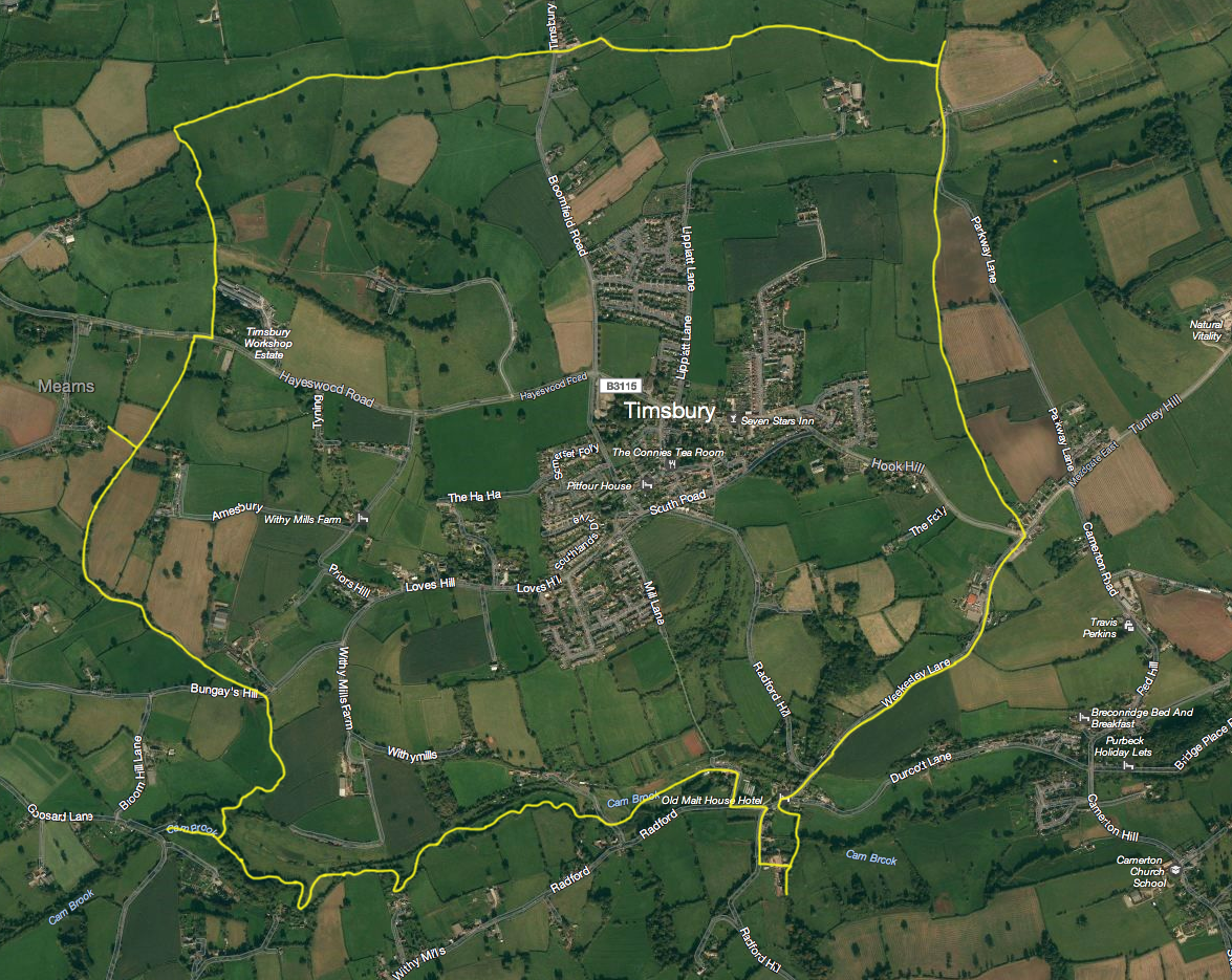
(courtesy of Bing Maps)